
'Unsurvivable' Hurricane Helene races towards Florida
Parts of Florida face "unsurvivable" conditions when Hurricane Helene hits later Thursday, the US weather service said, warning that howling wind will drive destructive waves and storm surge as high as 20 feet (six meters) onto the low-lying coast.
Residents fled ahead of the incoming hurricane amid mass evacuation orders.
The fast-moving storm was a Category 2 mid-morning Thursday, the National Hurricane Center (NHC) in Miami said, packing wind speeds of 105 miles (169 kilometers) an hour as it churns over the warm waters of the Gulf of Mexico.
The NHC said Helene -- which it described as one of the largest Gulf hurricanes in recent decades -- is expected to make landfall at or near Florida's Big Bend coast in the evening and could develop into a Category 3 or 4.
Tampa and Tallahassee airports have already closed, and Florida Governor Ron DeSantis urged residents to rush preparations ahead of the "nasty" storm.
It's a "very dangerous hurricane," NHC director Mike Brennan said.
"We're expecting to see a storm surge inundation of 15 to 20 feet (4.5-six meters) above ground level," he said. "That's up to the top of a second story building. Again, a really unsurvivable scenario is going to play out here in this portion of the Florida coastline."
"In addition to that storm surge, you're going to have destructive wave action on top of that, that can destroy houses, move cars, and that water level is going to rise very quickly," he said. "Winds are going to penetrate well inland."
The NHC warned of up to 20 inches (51 cm) of rain in isolated spots, and potentially life-threatening flooding as well as "numerous" landslides across the southern Appalachians further inland.
Several states are in the potential path. Georgia's capital Atlanta, a metropolis of some five million people, is forecast to experience tropical storm-force winds and as much as 12 inches (30.5 cm) of rainfall, which authorities warn could bring flash flooding.
Most of Georgia, which like Florida is under a state of emergency, was placed on flood watch, while Tennessee -- more than 300 miles (482 km) from the Gulf Coast, is bracing for tropical storm conditions statewide.
The White House said President Joe Biden's administration "stands ready to provide further assistance to Florida, and other states in the path of the storm."
DeSantis mobilized the National Guard and positioned thousands of personnel to prepare for possible search and rescue operations and power restoration.
- Sandbags, boarded windows -
The hurricane warning encompasses a 250 mile (202 km) stretch of coastline from Tampa Bay to Panama City, on the Florida panhandle.
A direct impact was likely in the Tallahassee region, where coastal communities already looked like ghost towns by Wednesday afternoon.
In Crawfordville, potentially in the storm's direct path, wheelchair-bound residents of the Eden Springs Nursing and Rehab Center were evacuated by bus.
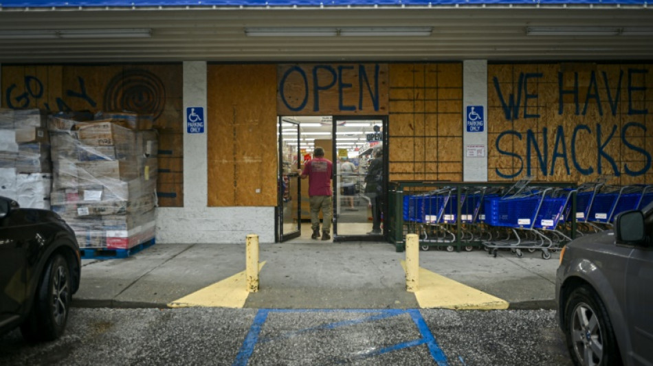
Other locals loaded up on gas and supplies, filling sandbags and boarding up homes and businesses.
"I expect the water to come up and just don't want it to get in the house," Clearwater Beach resident Jasper MacFarland told AFP, as he built a barrier with sandbags to "keep as much water out of the house as possible."
Helene could become the most powerful hurricane to hit the United States in more than a year.
Category 3 Hurricane Idalia hit northwestern Florida in August 2023.
Meanwhile Hurricane John, which killed three people when it slammed into Mexico on Monday but then dissipated, regained hurricane strength Thursday and was expected to again strike the country’s Pacific coast, Mexican officials said.
At 1200 GMT John was 56 miles (90 km) from the southern port city of Lazaro Cardenas in Michoacan state and was packing winds of 71 miles an hour (115 kmh), the NHC said.
Researchers say climate change likely plays a role in the rapid intensification of storms, because there is more energy in a warmer ocean for them to feed on.
burs-mlm/sms
Ch.Hutcheson--NG


